Presented at: Good Tech Fest
Presented on: 05/20/2020
Rapidly deployed GPS-enabled surveying tools, and the understanding that can be derived with the aid of geospatial reporting, can play a key role in providing targeted assistance to those in need.
Back in 2012, while wrapping up the counts for the cities of Quincy and Brockton, MA, we decided it was time to make the move to mobile tech. The US Department of Housing and Urban Development (HUD) recognized the viability of this early work by licensing the “Point in Time Counting Tool” app from Simtech and subsequently contracted with us to enhance it even further. Simtech has built upon this work with HUD through the release of the Counting Us mobile app and the Point in Time Regional Command Center that it is integrated with. Our tools are now helping regions throughout the country to automate their annual point in time counts.
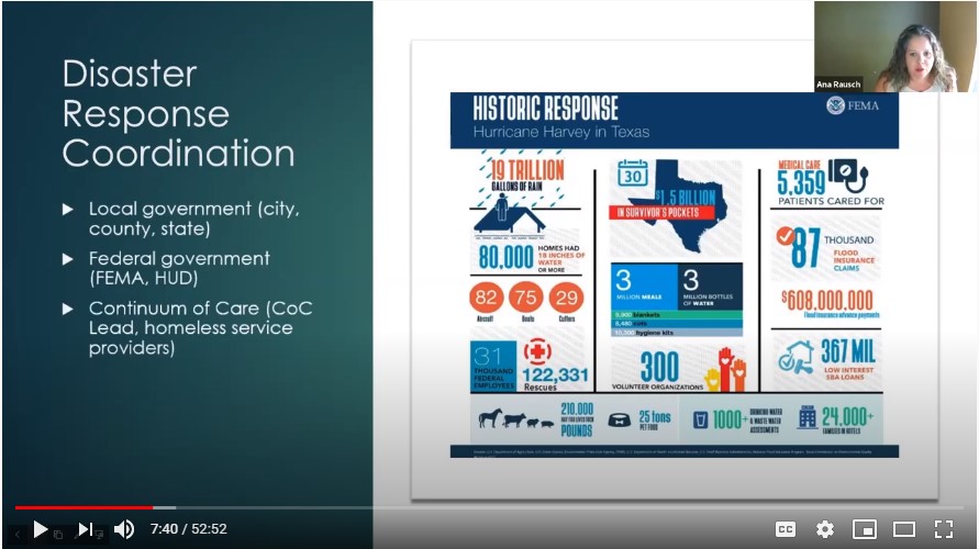
In addition to supporting automated PIT counts in forty-seven (47) regions across the US in 2019, the technology has also been used to support a rapid-response to natural disasters and Covid. For example, Texas Balance of State and Houston were able to quickly deploy the app to help triage over two-thousand people who had become homeless due to the flooding as a result of hurricane Harvey. Using this tech, volunteers and first responders in regions without internet access are able to still complete geo-tagged surveys and submit them when the user comes back online. This enables this vital data capture to still continue even during times when the entire grid is offline.
It is our hope that by sharing this work that we can propel the discussions forward on the steps that need to be taken to deploy technologies that will enable our communities to more readily respond to crisis – whether the crisis takes the form of the slow progression of economic inequality or the fast-paced destruction of hurricanes or wildfires.